Waking up to the gentle patter of rain on the roof, I embraced the start of a new day, a day that promised exploration in the picturesque Syunik region of Armenia.
I had set my sights on an early start, hoping to catch the first rays of sunshine gracing the lush green slopes of Syunik. However, as for the past week, luck had eluded me, as the persistent rain showed no signs of relenting.
My approach to travel, and life in general, is to avoid dwelling on hypothetical scenarios and make the most of the present situation. So, trading a few more hours of sleep for the rain seemed like a reasonable choice.
Unexpected Encounters at Night
Finally ready to attack the day, I savored the quiet solitude of the empty dorm room, a pleasant surprise courtesy of the owner. Little did I know, the previous night’s encounters would shape the day ahead.
In a shared space, I crossed paths with two French travelers who, despite their common nationality, weren’t travel companions. Philippe, an elderly gentleman, exuded an infectious energy even at late hours. Our conversation, though hindered by my limited French, seamlessly transitioned into English. Philippe’s leisurely exploration of Armenia resonated with the cautious curiosity one employs when unwrapping a cherished gift.
The second traveler, Charles, was a courageous young man with audacious plans. He wasted no time in sharing his intention to hitchhike eastward, toward the border with Azerbaijan, the very next day. Recent news had tainted some Armenian villages due to conflicts between the two countries.
Charles aimed to visit these areas, speak to the inhabitants, and report on the situation, unburdened by fear. My pragmatic nature led me to raise questions about the language barrier, his choice of a tent as sole shelter, and his unfamiliarity with even just the villages’ names—leaving me genuinely puzzled.
I mentioned my own travel plans, bound for the southernmost town in Syunik and Armenia, named Meghri. To my surprise, Charles expressed a keen interest, even though he had never heard of Meghri.
Despite my inclination for solitude, I momentarily set it aside and extended an offer for him to join me. With this decision made, we prepared for a long day of navigating some of Armenia’s challenging roads.
En Route through Syunik, the Gem of the South
Our journey took us through the stunning landscapes of southern Armenia, known as Syunik, a region that boasts diverse terrains and cultural landmarks, all packed into a relatively small area.
Much like the previous week, our journey began with intermittent rain. Regrettably, most of our planned stops had to be postponed due to the weather. Faced with this reality, I redirected our path to Goris cave dwellings, located just outside the town where we had spent the night.
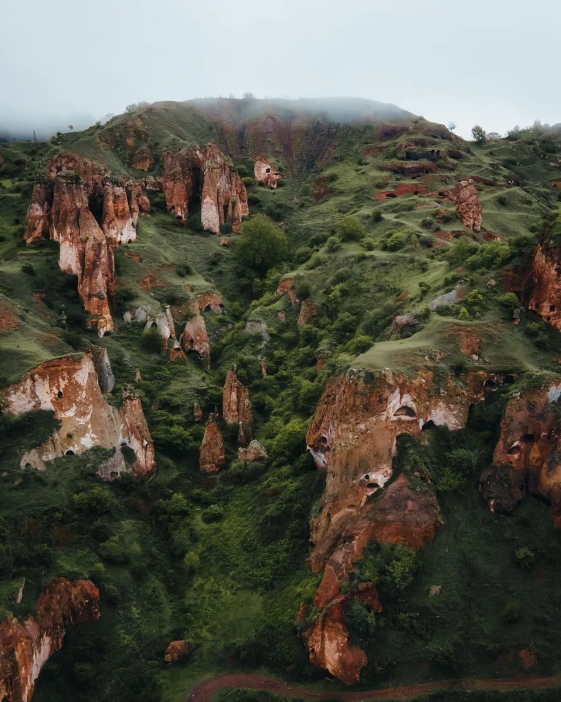
The Mystical Goris Cave Dwellings and Hoodos

The Syunik region is renowned for its abandoned cave settlements, where caves formed into towering rock pinnacles were inhabited for a long time. These geological formations, known as Hoodoos, can reach up to 15 meters in height in the area, creating an otherworldly atmosphere—especially when shrouded in fog.
How are Hoodos formed?
These formations are typically made of sedimentary rock, such as limestone or sandstone, which is susceptible to erosion by natural forces like wind, water, and temperature fluctuations. The Syunik region is part of a tectonically active area, and over millions of years, movements in the Earth’s crust led to the uplifting of these sedimentary rock layers.
Once these rock layers were exposed to the surface, they became vulnerable to erosion. In the case of the Syunik region, water played a significant role as it carved out valleys and canyons, gradually exposing the underlying rock formations. In addition to physical erosion, chemical weathering processes also took place. Rainwater, containing weak carbonic acid formed from carbon dioxide in the atmosphere, slowly dissolved the calcium carbonate in the limestone, leading to the creation of various fissures, cavities, and caves within the rock.
As the chemical and physical processes continued over millennia, some of the cracks and fissures in the limestone expanded into larger cavities and cave systems. People then adapted and expanded these natural caves into habitable spaces.
Historically, these caves were inhabited as far back as the 5th century AD, and their abandonment spanned from the 18th to the 20th century. As we approached them from a distance, they appeared like watchful eyes, a perception further heightened by the presence of a cemetery below, almost merging with the settlement.
Upon closer examination, we discovered that the caves were intricately carved into the rocky pinnacles, often in challenging locations.
While we assumed there must have been stairs to access them, our reverence for their historical significance prevented us from attempting entry. Instead, we sat in contemplation, imagining life within these ancient dwellings.
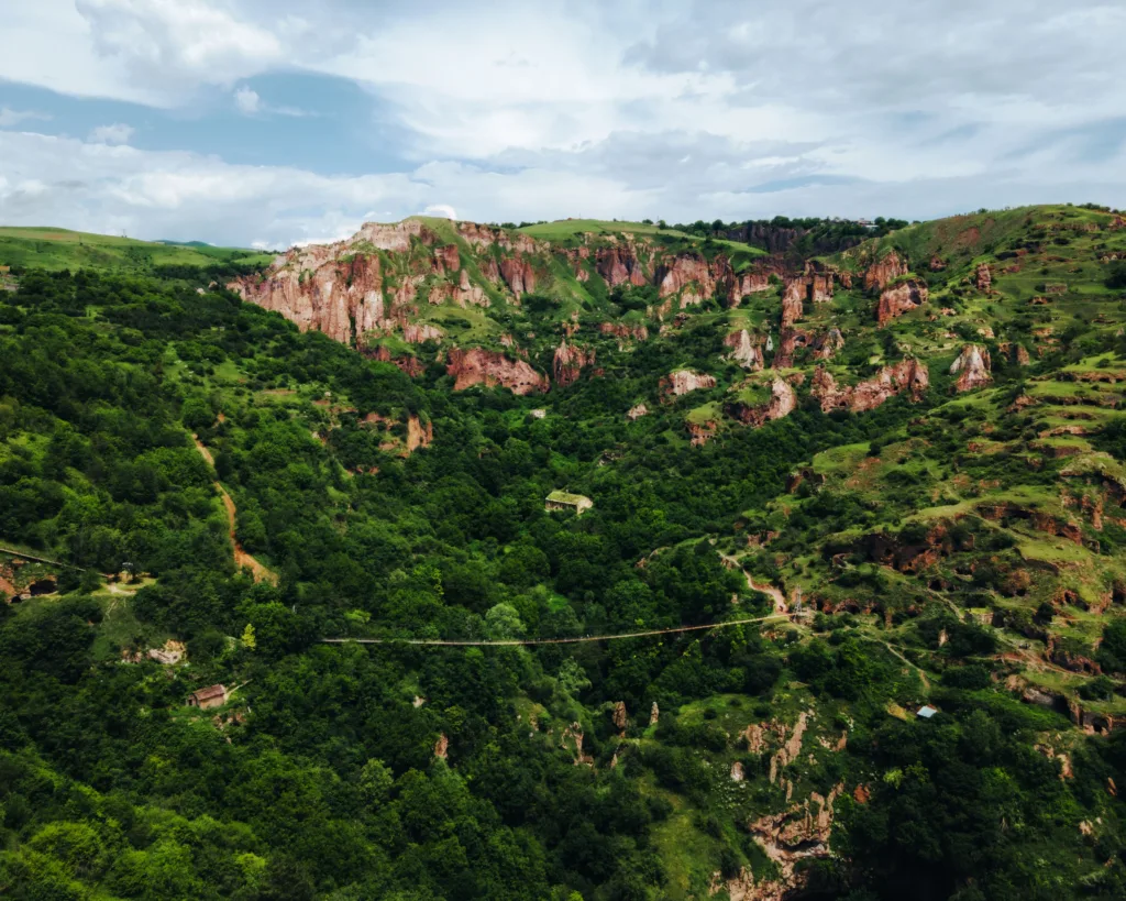
The Peak of Cave Civilizations in Khndzoresk
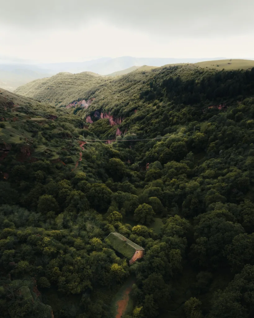
Resuming our journey, we set our sights on Khndzoresk, celebrated for its cave complexes nestled in a valley near Goris. The road to Khndzoresk revealed an enchanting landscape, with the typical Syunik Hoodoos dotting the surroundings.
Khndzoresk proved to be a remarkable tourist destination. Most of the caves were situated on the opposite side of the valley, accessible via wooden stairs leading down towards what claimed to be the world’s longest swinging bridge. This bridge opened up a captivating view, especially in the spring when the landscape was lush green, and the moody weather added a touch of mystery.
Our adventure continued as we ventured across the swinging bridge, with its substantial sway and dizzying drop. Fearless of heights, we relished the experience, especially since we had the bridge almost entirely to ourselves. On the other side, a series of caves awaited exploration—some compact with a single chamber, while others formed elaborate complexes with various layouts.
Sadly, most of these caves now stood empty, a natural consequence of the move to more modern villages, a transition that unfolded slowly, but was completed during the latter half of the 20th century. However, some evidence of this architectural evolution remained. Still-standing houses, the main church, a beautiful structure that defied our expectations, particularly with its intricately decorated interior, and the empty interiors of the caves themselves, which of course gave a lot of insight.
As we ventured further into the remnants of the village, the caves grew not only in number but also in complexity. The caves were throughout the centuries expanded and improved by carving out chambers, rooms, and even multi-story structures within the rock. These dwellings were often interconnected through narrow passages and tunnels, creating entire underground communities.
The interiors of these cave dwellings were designed with niches for storage, hearths for cooking and heating, and sometimes even small chapels or churches. The caves were made comfortable and functional, despite their primitive appearance from the outside.
Intriguingly, Khndzoresk, at its zenith, was home to over 15,000 people—an astonishing thought given its current state.
Our path led us to the new village atop the hill on the opposite side of our car. Charles and I decided to head back to continue exploring Syunik, weather permitting.
A Colorful Diversion and a Surprisingly Authentic Lunch
As we resumed our journey, vibrant red and purple flowers in the fields provided the only bursts of color on an otherwise muted day. Along the route, we crossed one of the many mountain passes typical of Armenian road trips. Here, we stumbled upon an unexpected and well-deserved lunch break.

Armenian restaurants had presented a one-dimensional experience throughout my trip, primarily offering basic dishes like Dolma (grape leaves filled with rice and/or meat) and the ubiquitous Shawarma. Curiosity led me to inquire about this culinary consistency along the way.
I hadn’t been able to find restaurants that served traditional food consistently, but more so spots that had a majority of basic dishes, such as Dolma (grape leaves filled with rice and meat), and the classic Shawarma.
As I asked people along my journey, I discovered that the reason why finding real traditional Armenian food can be arduous is that families already have that kind of food at home, especially in the countryside. Therefore, since the tourism industry isn’t as developed as one might think outside of the main hotspots, having a restaurant with the same food that people eat at home wouldn’t really work. Or at least that’s the conclusion we came to.
Our lunch break defied expectations, starting with the location itself—an impeccably renovated room with arched ceilings adorned with rock formations resembling the hoodoos we had marveled at earlier. The homemade compote, locally sourced cheese, and succulent lamb barbecue harmonized perfectly with the rustic ambiance, creating a memorable stop along our journey.
Emerging from the Mist
Leaving the restaurant, we were jolted back to reality by the thick mist that enveloped everything around us. Navigating through the dense fog, I found myself guessing the car’s location.
The air had transformed from the hot and humid climate that I had had enough of in Yerevan to a refreshing chill, marking a stark contrast.
Despite the ethereal ambiance, the memory of our delightful meal still lingered, and the comfort of our vehicle soon refocused our attention on the adventures awaiting us.
As we pressed forward, little did we know that this day would continue to unfold with more unexpected encounters and breathtaking sights.
Our drive felt like an unintended discovery, a well-kept secret we weren’t supposed to know but had become entangled in. Here and there, we caught glimpses of the distinctive landscapes of Southern Armenia, where rugged peaks occasionally materialized around tight corners, merging seamlessly with the mist, which crowned them with pristine snow.
One of the next stops was the renowned Tatev Monastery, an iconic historical and cultural site dramatically perched on a cliff overlooking the Vorotan River Gorge. In recent years, Tatev had gained recognition as a major Armenian tourist attraction, luring visitors not only for its spiritual significance but also for the stunning natural beauty that surrounded it.
Our encounter with Tatev was rather peculiar. The thick fog made it impossible to see the complex from a distance, and we only recognized the entrance when we stumbled upon it via a challenging road.
Tatev Monastery: A Testament to History
Despite my futile attempts to capture the fog-shrouded surroundings on camera, the Tatev Monastery left an indelible impression. Revered for its architectural beauty, the monastery’s origins trace back to the 9th century when it played a pivotal role as a center of learning, culture, and spirituality in medieval Armenia.
Walking on the ancient stone floors, one couldn’t help but admire the intricate stonework, exemplified by the Khachkars, which are characteristic of Armenian craftsmanship. The Surb Astvatsatsin Church, added in the 13th century, still contained preserved frescoes, offering a glimpse into the past.
Surrounding the churches, the Vardapet’s House served as the residence for the clergy and scholars who contributed to the monastery. Adjacent to it, the museum housed numerous artifacts, manuscripts, and historical information about Tatev Monastery and Armenian history, encapsulating its cultural significance.
The fog, in a way, acted as a temporary separation from the outside world, allowing us to immerse ourselves in the history and essence of Tatev.
For most, Tatev might be known primarily as a church with a breathtaking view, and while that’s undoubtedly true—as I later confirmed—it is also so much more.
You can learn more about Syunik’s history and traditions by viewing, and possibly experiencing, the various resources available here.
But as the rain began to fall again, we remembered that our ultimate destination, Meghri, still lay quite a distance away.
Descending to Kapan and Ascending to Meghri Pass
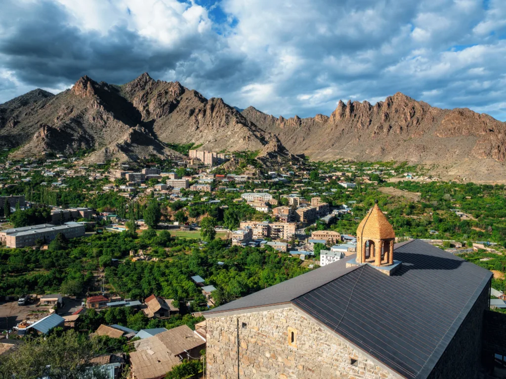
Driving for extended periods in Armenia typically involves navigating steep mountain roads and tight switchbacks. On this occasion, we descended through these roads, reaching Kapan, the southernmost significant town in the country. Surrounded by picturesque scenery, with Mount Khustup, the highest peak of the Katar Mountains, in the backdrop, Kapan serves as the administrative center of Syunik.
Unfortunately, our schedule did not allow for exploration, but Kapan appeared intriguing and deserving of more time on a future visit.
Then, we ascended once more, this time towards Meghri Pass, one of Syunik’s and Armenia’s highest mountain passes.

At the end of some of the valleys visible from the Meghri Pass, these alpine lakes mark the endpoint for some of the best hikes in Armenia.
I hadn’t yet been close to snow on this trip, but the further we got up the mountain, the more the rain started to transform until we eventually reached the top. If prior to this moment the chalky fog covered most of our view, now the brilliant white snow made sure that our ascent to the top resembled a sort of common imagery of heaven.
The Intriguing Sight of Iranian Trucks
Amid this picturesque scene, the thundering presence of numerous trucks became apparent. Most bore Iranian license plates, a novelty for me. I couldn’t help but contemplate the lives of the truck drivers who navigated these treacherous mountain passes for hours on end, day after day.
These individuals were unsung heroes for many communities in Syunik and beyond, maintaining essential supply routes through challenging terrain.
As we began our descent, the thick fog that had surrounded us for most of the day suddenly lifted. Ahead, beyond the clouds, the sun illuminated the arid mountains near the border.
At Last, Meghri
It was dusk as we sat the wheels on the Meghri asphalt. We drove around a bit more to look for a good spot to enjoy the diminishing light, eager to fly my drone after such a long day at the wheel.
We stopped almost in the heart of Meghri, surrounded by houses. The difference with the previous towns of Syunik was already apparent and striking.
A few kids were in the streets now that the rain had stopped, playing with a ball or just running through the houses up and down the stairs.

The view I witnessed from the drone that day, with darkness engulfing the mountainous landscape with an intensity that I had only seen before in videos of storms in the open sea, was hypnotic. It didn’t feel like a place anymore, more like a moment.
The chaos ensued on the ground, as the kids swarmed me and Charles and cars kept passing through, but up there everything was different.
Suddenly, two men approached us, curious to see what we were up to. More interested in inviting us into their home to have a drink than to see Meghri from above, they kept pushing for us to follow them, so I savored the last few moments, brought the drone down, and went along.
We stayed with them and the kids for about two hours. Naturally, with no language in common, we resorted to communicating through signs, pictures, sounds, and whatever else came to mind.
It was such a fun turn of events.
The more we spoke, the more delicacies they brought out for us to try.
Mind you, we were sitting in a room with an old table, an arranged bed, and miscellaneous stuff lying around – these kind people didn’t really possess much, but they shared whatever they had.
Dried persimmon, dried plums, figs, white cherries, some type of berries, homemade Oghi (Armenian Grappa), and everything else. As we said our goodbyes we didn’t even feel hungry enough to have dinner.
Charles and I headed to our accommodation for the night, tired but happy. We grabbed a couple of highly-deserved beers along the way.
The day spent exploring Syunik through literal ups and downs, gloomy weather at best, and cultural sightseeing was a success. The only thing to do now was sleep and hope for many other days like this